


Jura 14

Pascal Bernaud
User
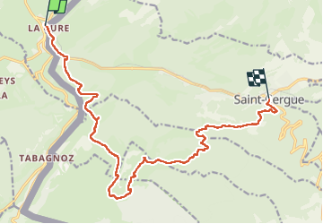

Length
17.4 km

Max alt
1670 m

Uphill gradient
720 m
Km-Effort
27 km

Min alt
1044 m

Downhill gradient
827 m
Boucle
No
Creation date :
2022-08-22 06:31:29.0
Updated on :
2022-08-22 13:29:24.147
6h56
Difficulty : Very difficult

FREE GPS app for hiking
 SityTrail
IGN / Geographical institutes
SityTrail Plus
The world is yours!
About
Trail Walking of 17.4 km to be discovered at Bourgogne-Franche-Comté, Jura, Les Rousses. This trail is proposed by Pascal Bernaud.
Positioning
Country:
France
Region :
Bourgogne-Franche-Comté
Department/Province :
Jura
Municipality :
Les Rousses
Location:
Unknown
Start:(Dec)
Start:(UTM)
275228 ; 5149962 (32T) N.
Comments